New Models Available!
Features
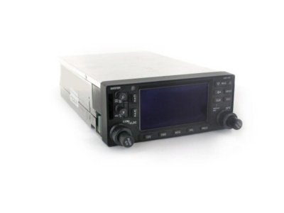
The GNS-430 has been replaced by the GNS-430W with WAAS capabilities
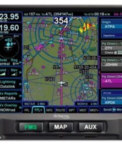
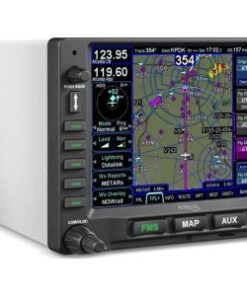
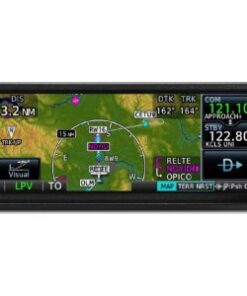
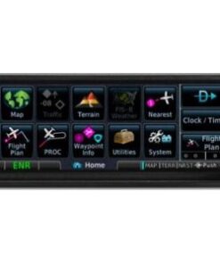
Combines 10 watt VHF communications transceiver, VHF navigation and UHF glideslope receivers, 12-channel GPS receiver with color moving map
760 channel VHF comm with 25khz spacing; software configurable for 2280 channels (8.33 kHz spacing) for Europe
Provides both course deviation and optional roll steering outputs to aircraft flight guidance systems which will enable ARINC 424 lateral guidance procedures including IFR arrivals, departures and approaches
Automatically will nominate appropriate VOR and localizer frequencies for VHF navaid
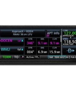
Sends correct ATIS, approach, clearance, tower or ground control frequency to the comm radio at the touch of a button
16-color, active-matrix LCD measuring approximately 2″ high and 3″ wide with a resolution of 128 by 240 pixels
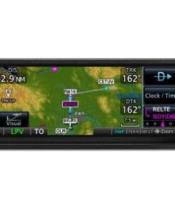
Cartographic database displays geopolitical boundaries, federal interstate highways, state routes, major local thoroughfares, plus railroads, rivers, coastlines and lakes
Can be interfaced to main indicators such as KI-202/203/204/206/208/208A/209/209A as well as KPI-552/553A
Can be interface to Bendix/King RMI units such as KI-229 and KNI-582
Can tune most panel mount DME and remote mount DME units
Interaces to ARINC 429 EFIS systems such as Sandel SN3308 and Bendix/King EFIS 40 & 50
RS-232 and RS-422 serial ports for interfacing
ARINC 429 digital output (GAMA standard) for left/right analog course deviation, ng, encoded or greycode altitude, and basic fuel flow sensor links
Fuel Flow page configurable to allow for simultaneous display of left and right engine fuel flows
ARINC 429 digital output compatible with some autopilots which can accept ARINC 429 roll-steering information
ARINC 429 output data can be used with digital to analog adapter such as Allied Signal KA-90 to produce roll-steering signal used by autopilots systems requiring analog signal
Accepts RS-232 fuel flow data from external sources
28 Volt or 14 Volt operation
TSO’d
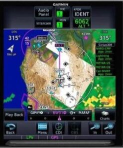
Interfaces to BF Goodrich WX-500 Weather Mapping Sensor and Skywatch Traffic Advisory System for combined moving map display with nav data and weather/traffic information
Interfaces to Ryan 9900B / 9900BX TCAD and Goodrich Skywatch to display traffic information
XM WX satellite weather service via GDL 69
Specifications
COVERAGE: Americas or International AIRPORTS: Identifier, city/state, country, facility name, lat/long elevation, fuel service, control, approach information
VORS: Identifier, city/state, country, facility name, lat/long, frequency, co-located DME/TACAN, magnetic variation, weather broadcast NDBS: Identifer, city/state, country, facility name, lat/long, frequency, weather broadcast
INTERSECTIONS: Identifier, country, lat/long, nearest VOR FREQUENCIES: Approach, arrival, control area, departure, Class B, Class C, TMA, TRSA-with sector, altitude and text usage info, also, ASOS, ATIS, AWOS, center, clearance delivery, ground, pre-taxi, tower, unicom, localizer and ILS
RUNWAYS: Designation, length, width, surface, lighting, pilot-controlled lighting freq. FSS: Identifier, reference VOR, freq. usage
ARTCC: Identifier, freq. usage MSA: Minimum safe altitude along and in proximity to active flight plan
APPROACHES: Non-precision and precision approaches throughtout the database coverage SIDS/STARS: Contains all pilot-nav SIDs and STARs
WAYPOINTS: 1000 user-defined FLIGHT PLANS: 20 reversible; up to 31 waypoints each
EMERGENCY SEARCH: 9 nearest airports, VOR’s, NDB’s, intersections, or user waypoints; 2 nearest FSS with frequncies; 2 nearest ARTCC frequencies ALARMS: Arrival and CDI, timers, SUAs less than 10 min, 2NM and insude SUA
RECEIVER: PhaseTrac12, 12 parallel channel receiver, simultaneously tracks and uses up to 12 satellites ACQUISITION TIME: 12 seconds (warm), 45 seconds (cold)
UPDATE RATE: 1/second, continuous ACCURACY: 15 meters (49 feet) RMS, 1.5 meters with differential corrections
NAV FEATURES: Pilot-defined Course Selection and Waypoint Hold, Closest Point of Approach, Departure and Arrival Frequencies, Approach Navigation using published approach procedures stored on NavData card, Terminal Navigation using SIDs/STARs from NavData card PLANNING FEATURES: True Airspeed, Density Altitude, Winds Aloft, RAIM Availability, Sunrise/Sunset Times, Trip and Fuel Planning, Vertical Navigation (VNAV)
INTERFACES: ARINC 429, Aviation RS-232, CDI/HSI, RMI (digital: clock/data), Superflag Out, altitude (serial: Icarus, Shadin-Rosetta, encoded Gillham/Greycode), fuel sensor, fuel/air data MAP DATUMS: 124 predefined, 1 user defined
VOR FREQ. RANGE: 108.00 MHz to 117.95 MHz VOR/LOC COMPOSITE: 0.50Vrms/0.35Vrms
CDI OUTPUT: +-150mV Full Scale CENTERING ACCURACY: +-2.0 deg.
FLAG SENSITIVITY: -103.5 dBm DME CHANNELING: 2×5 available
AUDIO SENSITIVITY: -103.5 dBm for 6 dB S/N with 1 kHz 30% mod. VOR AUDIO OUTPUT: -103.5 mW minimum into 500 ohm load; external amplifier required
GS FREQ. RANGE: 329.15 MHz to 335.00 MHz GS CDI OUTPUT: +-150mV Full Scale
LOC FREQ. RANGE: 108.10 MHz to 111.95 MHz LOC CDI OUTPUT: +-150mV Full Scale
LOC ACCURACY: LOC Flag Sens.: -103.5 DBM
SIZE: 6.25″W x 2.65H x 11.0″L WEIGHT: 6.6 lbs.
DISPLAY: Color LCD POWER: 14/28 VDC
CERTIFICATION: GPS: TSO C129a, Class A1 (en route, terminal, and approach) VOR: TSO C40c LOC: TSO C36c GS: TSO C34e VHF COM: TSO C37d, Class 4 and 6 (transmit) and TSO C38d, Class C and E (receiver) VHF FREQUENCY RANGE: 118.000 MHz to 136.976 MHz
COMM TRANSMIT POWER: 10 watts min. COMM MODULATION: 70%
RECEIVER SENSITIVITY: 2.0 microvolts for 6dB S/N with 1 kHz 30% mod. COMM CHANNELS: 760 (25 Khz spacing); configuration for 2280 channels (8.33 kHz spacing) also provided
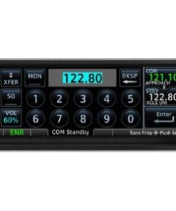
FREQUENCY DISPLAY: Upper left corner of active matrix LCD, 2-lines with active freq. above standby SQUELCH SENSITIVITY: 2.0 microvolts typical
Be the first to review “Garmin GNS 430 IFR Panel Mount GPS/COM/NAV”
Related products

Reviews
There are no reviews yet.